
![]() Small
Islands Management
Mitigation Program
Small
Islands Management
Mitigation Program
INTRODUCTION
Environmental management of coastal developments should incorporate a ”life
cycle” perspective, whereby potential impacts are managed over the entire life
of the project, including initial resources used, site design, development and
construction, all inputs to its operation, and disposal (UNEP 2005). The site
design and construction process of a development can have large impacts, such as
soil erosion, changes in water runoff,
and damage to natural environments (U.S. National Park Service 1992). A wide
variety of stresses, including the density of settlement, coastal proximity,
infrastructure and alteration of terrestrial and marine habitats must be
considered; yet, environmental changes due to tourism development can be
counteracted by means of better construction, engineering, architecture, design
practices and monitoring (UNEP 1997).
1) SITE DESIGN
![]() Site
design considerations must stem from a respect for the landscape and an effort
to understand the relationships among soil, water, plant communities and
associations, and habitats (IRF 1996). Also, sustainable site design must
reflect ecosystemand cultural conditions; stress support for environmental
responsiveness and regeneration, versus creating new environmental communities;
focus attention on and appreciation for the natural conditions of the site and
focus on adaptive use of existing resources to save costs and stress in the
construction process (United States Department of the Interior 1993). The
Bahamian environment was a foremost consideration for BMPs that were employed as
tools in site design and construction practices. Site design incorporated the
utilization of native vegetation for landscaping, maintenance of coastal
integrity via integration of coastal setbacks, the establishment of vegetation
corridors between structures and limitations on the amount of cleared land.
Site
design considerations must stem from a respect for the landscape and an effort
to understand the relationships among soil, water, plant communities and
associations, and habitats (IRF 1996). Also, sustainable site design must
reflect ecosystemand cultural conditions; stress support for environmental
responsiveness and regeneration, versus creating new environmental communities;
focus attention on and appreciation for the natural conditions of the site and
focus on adaptive use of existing resources to save costs and stress in the
construction process (United States Department of the Interior 1993). The
Bahamian environment was a foremost consideration for BMPs that were employed as
tools in site design and construction practices. Site design incorporated the
utilization of native vegetation for landscaping, maintenance of coastal
integrity via integration of coastal setbacks, the establishment of vegetation
corridors between structures and limitations on the amount of cleared land.
a) Protected Areas
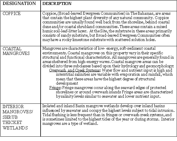
Protected areas were incorporated into the site design for Baker’s Bay Club as an essential component to achieving the environmental goals outlined in the EIA (2004).(link) Onsite protected areas include two preserve sites, two small wetlands and coastal buffer zones (see below) totaling approximately 158 acres/ 64 hectares. The preserve areas contain wetlands, creeks, coastal areas and many unique terrestrial communities (see table below). Thus, albeit small in total area, these areas protect critical habitats and are conduits for associate flora and fauna (e.g. migratory birds and land crabs).
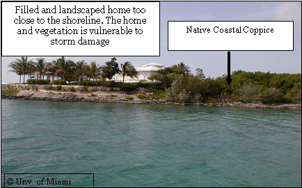
b) Coastal Setbacks
A
“coastal development setback” or coastal buffer zone is defined as a prescribed
distance to a coastal feature, such as a line of permanent vegetation, within
which all types of development are prohibited. In site design, the prudent use
of coastal development setbacks and the maintenance of coastal vegetation can
ensure that coastal infrastructure remains intact (Cambers 1997). Due to their
dynamic nature, the most effective way to conserve beaches and protect property
is to allow beaches the space to move in a seaward direction during accretion
phases and in a landwards direction during natural erosion phases. Setbacks are
developed for beaches based on the historical changes in the coastline position,
predicted changes in the position of the dune line and coastline likely to occur
during a major hurricane, wave energy, changes in coastline position likely to
occur as a result of the predicted rise in sea level and coastal
geomorphological features such as exposed beach rock and planning considerations
such as lot size.
Coastal setback guidelines followed those outlined in the Planning for coastal change report, Planning for coastline change guidelines for construction setbacks in the Eastern Caribbean Islands (Chambers 1997). The coastal setbacks for the property were designated based on the geomorphology of the coastline and the areas were designated as protected areas where there should be no traversing and vegetation is too remain intact.
The type of coast and setback distance for Baker’s Bay Club (EIA 2004).
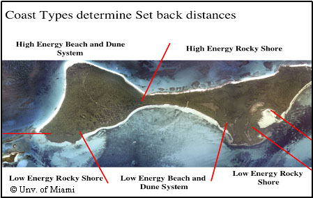

|
High Energy Beach and Dunes |
10 meters back from Dune Crest or high point of dune system. For restored dune areas, dune crest is based on restored shore profile. |
|
High Energy Rocky Shores |
5 meters back from cliff crest, well above white zone of the upper tidal platform |
|
Low Energy Beaches |
15 meters back from permanent vegetation line, avoiding palm-dominated scrublands that are prone to flooding. |
|
Low Energy Rock Shores |
15 meters back from permanent vegetation line. |
|
Mangrove Coastlines |
No construction or setbacks, mangrove coastlines are within proposed preserve area |
2) BEST MANAGEMENT PRACTICES FOR CONSTRUCTION
In many areas, particularly coastal sites, it has been found that waste and emissions from the construction phase can be more disturbing to the local environment than the operational phase (UNEP 2005). Construction BMP’s were developed to standardize equipment maintenance and usage, minimize erosion and runoff, to prevent the clear-cutting of vegetation and to maintain the island’s natural ecology. Scheduling of activities was determined by the most appropriate times (e.g. avoiding ecological disturbance during sensitive periods for conservation species and avoidance of excessive clearing during the rainy seasons). Operational planning focused on minimal land clearing, hand-clearing versus bulldozing where required and minimal vehicle movement to reduce compacting. Control devices (e.g. suction dredges, turbidity barriers) and infrastructure to abate erosion, sedimentation and run-off were incorporated.
Pre-mitigating construction measures that should be accomplished to facilitate
achievement of BBC environmental goals and
prevent excess impacts include:
· Planning: project design can reduce impacts,
· Scheduling: determining most appropriate/inappropriate times for project activities (e.g., avoiding sensitive periods for species; consideration of weather-related seasons/events, etc.). Scheduling considerations are also mentioned in the EIA.
· Operational: considering the manner in which project activities are carried out (e.g., minimal land clearing; hand-clearing vs. bulldozing, etc.).
· Technological:
using control devices to prevent or restrict the release of deleterious
substances (e.g., use of filters and
scrubbers, etc.).
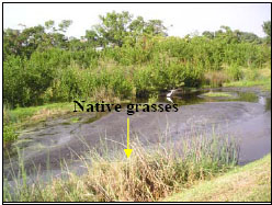
3) BERM AND SWALE PROTECTIVE TRANSITION AREAS
Berm and swales are man-made or natural vegetated areas shaped or graded that are designed to: 1) to provide a vegetated transition corridors that can serve as a bio-filter of storm water run-off, 2) minimize construction impacts on protected areas, and 3) provide habitat for native flora and fauna. They are commonly used and are among the simplest and most cost-effective measures to control storm water run-off (Deletic & Fletcher 2006). In addition, due to the increasing concern of natural wetlands as repositories for non-point sources of pollution, the U.S. Environmental Protection Agency (EPA) along with other organizations, have devised a set of Best Management Practices for natural wetlands that receive storm water run-off and these practices include structural measures such as berm and swales.
Applications and Designs of Berm and Swales
By example, in Florida storm water run-off is now considered the state’s leading source of water pollution, and contributes approximately 80-95 percent of the heavy metals that enter the water. Summary statistics from a selection of studies on swale performance as a method of storm water control suggest that these systems when properly designed can remove approximately 72 percent, 52 percent, and 45 percent of total suspended solids, total phosphorous, and total nitrogen, respectively. Removal rates of cadmium, copper, lead, and zinc by swales have been estimated to be 42 percent, 51 percent, 67 percent, and 71 percent, respectively5. Also, advantages of berm and swales over conventional storm water management practices include the reduction of peak flows, the promotion of runoff infiltration and lower capital costs (Deletic & Fletcher 2006).
· Berm
and swales should not be constructed in gravelly and coarse sandy soils that
cannot easily support dense
vegetation.
· Alkaline soils and subsoils should be used to promote the removal and retention of metals.
· Care should be taken to not compact the soils. Infiltration rates greater than 0.2mm per second are recommended.
· Channels with a parabolic or trapezoidal cross-section with side slopes no steeper than 1:3 are recommended.
· Longitudinal
slopes should not exceed 2.5%. The width of the swale should be determined using
the Manning’s
Equation using a value of 0.25 for Manning’s n.
· As a rule of thumb, the total surface area of the swale should be one percent of the area that drains to the swale.
· Check dams can be installed to promote additional infiltration.
Limitations of Berm and Swales
· A thick vegetative cover is needed for swales to function properly.
· Berm and swales are impractical in areas of steep topography, very flat grades, or wet or poorly drained soils.
· Swales are not effective and may cause erosion when flow volumes/velocities are high.
Maintenance of Berm and Swales
Like any system, berm and swales must be maintained. Basic maintenance includes removing nuisances and excess vegetation, repairing eroded slopes, and weeding. It must be determined whether or not the homeowners or developers will be responsible for the upkeep and maintenance of the berm and swale systems. In order to prevent water pollution, the following is encouraged:
· Use nontoxic alternatives to fertilizers, pesticides, etc. whenever possible.
· Avoid the overuse of fertilizers, pesticides, etc. Instead, utilize native vegetation.
· Avoid dumping waste oil, chemicals, or yard trash into storm drains.
· Clean up trash and waste in your surrounding areas.
Case study: Baker’s Bay Club
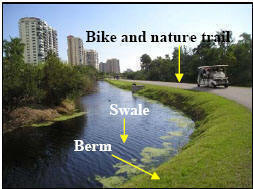
In order to comply with national efforts to protect wetlands, to halt encroachment into protected areas and to mitigate potentially harmful effects from storm water run-off, a berm and swale system was designed for Baker’s Bay Golf and Ocean Club. Additionally, by constructing trails made of soft asphalt pavement or mulch the berm and swale system will be used as a means to provide constructive, recreational and educational use of the natural areas in the vicinity of the wetlands. Examples of trails along the tops of berms used in Naples, Florida within a residential community are illustrated below.
Examples of Berm and Swales used in Naples, Florida.
References
EPA. Storm Water
Technology Fact Sheet: Vegetated (Berm) Swales.
http://www.epa.gov/owmitnet/mtb/vegswale.pdf
EPA. Protecting Natural Wetlands: A Guide to Stormwater Best Management Practices
http://www.epa.gov/owow/wetlands/pdf/protecti.pdf
Deletic A, Fletcher T
(2006) Performance of grass filters used for stormwater treatment-a field and
modeling study. Journal of Hydrology 317:261-275
Duke N, Bell A, Pederson
D, Roelfsema C, Nash S (2005) Herbicides implicated as the cause of severe
mangrove dieback in the Mackay region, NE Australia:
consequencesfor marine plant habitats of the
GBR World Heritage Area. Marine Pollution Bulletin 51:308-324
Milano G (1999) Restoration of coastal wetlands in southeastern Florida. Wetland Journal 11:15-24
United States Department
of the Interior, 1993. Guiding Principles of Sustainable Design. National Park
Service, U.S. Department of the Interior. 1992a
Environmentally Responsible Building Product Guide. Denver Service Center.
UNEP and World Tourism Organization. 2005. Making Tourism More Sustainable. A Guide for Policy Makers.
UNESCO,
Chambers, G. 1997. Planning for
coastline change Guidelines for construction setbacks in the
Eastern Caribbean Islands. Paris, 14pp.

![]()