 Coastal Ecology of the
Bahamas
Coastal Ecology of the
BahamasIntroductions
to the Islands of The Bahamas
Neil Sealey
Geology and Topography.
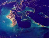
Abaco is a large and complex island which includes a considerable number of cays along its eastern shore, a feature that makes it quite different from its Atlantic counterparts on the Great Bahama Bank. Abaco occupies most of the eastern half of the Little Bahama Bank and extends for some 115 miles in an arc. The outer cays also extend for about the same distance but start and end some 35 miles further north, and generally follow a straight NW-SE line as far south as Elbow Cay. Abaco is in fact the second largest Bahamian island, over three times the size of Eleuthera for comparison. For the most part the island is at least five miles wide, but is broken up into smaller units at intervals by isthmuses such as Crossing Rocks in the south. Just north of Coopers Town there is in fact a complete separation into Great Abaco and Little Abaco Islands.
The relief is dominated by a complex ridge running along the eastern side of the island and reaching heights of 80-100 feet, with a maximum of 120 feet. Little Abaco Island lacks this ridge and is much flatter. Inland is largely flat rockland 5-15 feet above sea level, occasionally relieved by old beach ridges reaching 30-40 feet. The western shore is extensive wetland with mangroves eventually grading into wide tidal flats and an area on numerous small cays known as the Marls.
The line of offshore cays is the remnants of basically a twin dune ridge reaching 40-60 feet on most islands. None of these islands are more than half a mile wide, but some can be quite long, notably Great Guana Cay which extends for some six miles.
The northerly location of Abaco and its large size combine to give it one of the heaviest rainfalls in the Bahamas, along with a fairly pronounced winter season. Rainfall averages about 60” a year, and winter temperatures are cool, but do not reach the minimums of Grand Bahama and North Andros which are that much closer to the US. The Atlantic exposure does ensure that the NE Trade Winds are predominant throughout the year, but this same location has also made the island vulnerable to hurricanes heading northwards along the edge of the archipelago. Floyd in 1999 did considerable damage to the outlying cays.
The level of rainfall has supported extensive growth of the Caribbean Pine, which covers the island except where it has been clear-felled. This is mostly in the area of some 20 000 acres west and south of Marsh Harbour, which had a short spell as a sugar plantation in the 1970s, but was unsuccessful and abandoned. Much of this area is now a National Park, and commercial farms operate near Marsh Harbour and north of Treasure Cay.
Acklins Island
Geology and Topography.
Acklins is a substantial island almost identical in size to Cat Island at 150 square miles. Its northern section is very similar in topography to Crooked Island ,and can be considered an extension of it for structural purposes. The islands are separated by a shallow, island-filled, channel about 2 miles wide. This broad section of northern Acklins is low-lying, contains a large lake, and is only settled along the hillier northern coast, where the coastal ridge is present. Fragments of this ridge create a number of close inshore islands off the northeast corner.
South of Hard Hill, Acklins takes on the character of the Atlantic islands of the Great Bahama Bank. A long discontinuous ridge, multiple in places, reaches over 100 feet at several points, and extends all the way south along the east coast to Castle Island, a southern extension just offshore. West of the ridge is fairly continuous rockland of 10-20 feet elevation which faces the Bight of Acklins and contains most of the settlements.
Large uninhabited cays exist to the north and east on related outlying banks. To the north is Samana Cay (also known as Atwoods Cay), a somewhat smaller version of Rum Cay at 15 square miles. To the east are the Plana Cays (also known as the French Cays), which are little more than elevated sandbanks, although both islands have elevations of 60+ feet in the form of isolated hills overlooking a low wooded plain.
Climate and Vegetation
Acklins Island is rather drier than Crooked Island, but still attracts about 35” of rain a year, although this figure varies geographically and annually quite significantly this far south. The east coast is the edge of the bank and easterly winds are normal throughout the year.
The island was well settled by plantation farmers in the 18th century, and the settlements that remain are testimony to their presence. The ridgeland is well wooded, and there is much secondary forest over the rest of the island, despite the persistence of some small-scale farming.
Geology and Topography.
The cays and islands of the Bimini chain are unusual in their location on the lee side of a major bank. Altogether there are about ten small islands, but only North and South Bimini and Cat Cay are of any size. This is the result of the limited wind and wave action from the west across the Gulf Stream.
Most of North Bimini is a thin ridge reaching about 20 feet in elevation, although quite steep despite its low height, and this is the occupied area. To the north and west the land is without hills, and the western section is exclusively very low land, wetland and tidal creeks. The limited dry land in this area is the remains of a complex spit, although the large eastern limb is well formed and active at the present time.
South Bimini has developed rather differently, consisting of a similar low ridge facing the Florida Straits, but in this case it is backed by a mile or so of extensive wetland, and then by rockland, the total being some four miles of a very flat topography.
Climate and Vegetation
The rainfall reflects the northern location and averages 44”. Being well to the west on the Great Bahama Bank, it is not especially exposed to the NE trade winds, but is vulnerable to cold air masses from the nearby Florida peninsula in winter, which gives it quite variable weather conditions in that season.
North Bimini is essentially cleared of all vegetation apart form the uninhabited western sector, which is mostly mangrove swamp, although invasive casuarinas occupy much of the drier ground. South Bimini is also cleared of vegetation in the west, and much of the wetland has been reclaimed, but west of that there is still extensive broadleaf woodland, fairly luxurious as a result of the heavier rainfall, but vulnerable to salt water intrusion.
Geology and Topography.
Cat Island is the middle of the three islands on the eastern edge of the Great Bahama Bank, and is the smallest of the three at 150 square miles. Like them it is hilly and constructed from multiple fossil dune ridges flanked by a modern dune along the Atlantic coast for much of its length. It is noted for having the only elevation over 200 feet in the Bahamas, Mount Alvernia (originally Mt Comer, renamed by Father Jerome in the 1940’s) which reaches 206 feet.
Apart from a few flat lowland areas, mainly in the south of the island north of New Bight and south of Old Bight, the island is hilly throughout its length with no outlying islands or extensive wetlands. It does however contain a number of lakes on the lowland in the north and south and several creeks along the west coast. Like Eleuthera and Long Island, it was settled by the early Loyalist plantation owners, but agriculturally it has been the least successful, lacking much of the red clay soils that support pineapple cultivation in Eleuthera, and also suffering from an older more crystalline limestone surface which has not responded well to scarifying. The traditional slash and burn agriculture has almost died out and the absence of commercial agriculture has led to excessive depopulation.
Climate
Rainfall is generally comparable with that of Long Island, although only 30” per year was averaged from 1978-1990. Temperatures are also similar to Long Island, and exposure to the Atlantic ensures a steady NE Trade Wind presence throughout the year. Winters are pleasantly cooler due to the migration of the overhead sun, and in addition Cat Island does suffer from the impact of cold fronts, although these are much ameliorated by their distance from the North American mainland and their passage over warm water.
Vegetation is the classic broadleaf hardwood, generally known as coppice, much affected by human occupation, notably the slash and burn cultivation but including earlier plantation clearances.
Geology and Topography.
This is the northern component of the landmass surrounding the Bight of Acklins, a large shallow water carbonate bank which also contains Acklins Island in the east, and Long Cay (also know as Fortune Island) in the west. Crooked Island is slightly bigger than New Providence, and also consists of a long hilly ridge along its northern shores backed in the south by rockland grading into tidal creeks and marshland. In the west the large Turtle Sound Creek almost splits the island.
The landscape is particularly hilly, with many steep slopes in the north and elevations that reach 155 feet. In the east the hills quickly give way to rockland, and then wetland that becomes tidal flats and very shallow sea, the depth being less than 6 feet many miles offshore. Most of the Bight of Acklins is in fact less than 15 feet deep. There are a number of fairly large lakes in the east where the ridge thins out, and several smaller lakes trapped between curved ridges in the centre of the northern shores.
Long Cay is essentially an extension of the western arm of Crooked Island, separated from it by a channel about one mile wide. It is inhabited and has a small saltpan in the linear lake between the long smooth ridges that form the island. These reach just over 100 feet in the south, but the island is relatively narrow and easily accessible, although quite small at 9 square miles.
Rainfall in the center of Crooked Island is averaged at 43”, rather more than might be expected, and support for its extensive plantations in the past, and its many small villages today. The north coast is open to the Atlantic, and the NE Trade Winds which created the ridgeland, but inland the island is heavily wooded and includes much mangrove swamp, especially around the creeks in the west and the lakes in the east.
Geology and Topography.
This is a typical long narrow Atlantic margin island, measuring about 90 miles long but rarely exceeding more than 3 miles in width. The largest land masses, and broadest parts of the island, are in the north and south, which also hold the largest water lenses, and to a lesser extent between Tarpum Bay and Rock Sound in the south. Most of the island is narrow and hilly, especially in the north where there is a breach at the Glass Window. Between the Glass Window and Savannah Sound the island is unusual in having substantial cliffs on both shorelines. The geological structure in this area is a series of overlapping fossil sand dunes forming a low tableland frequently exceeding 100 feet in height. The highest point is 168 feet. Notable outlying islands, usually detached ridges, are Russell Island/St George’s Island (Spanish Wells), Current Island, Harbour Island and Windermere Island, all of which are inhabited. Low-lying rockland is limited in extent, but most evident in North Eleuthera, the name given to the triangular area north of the Glass Window; around Tarpum Bay; and in the far south.
The island forms the northeastern extremity of the Great Bahamas Bank, and has a strongly eroding coastline, with some evidence for bank margin collapse in the recent geological past, notably at Glass Window where the scalloped margin suggests bank margin retreat. The karstified surface limestone is generally sufficiently young to be scarified for agricultural purposes, and the island has been much altered by early plantation settlers and later subsistence farmers. Even today Eleuthera is an important agricultural producer with several large commercial farms.
Climate
Being in the northern part of the Bahamas, Eleuthera has a distinct if mild winter season, and is affected by cold fronts from North America. This also amplifies the winter rain in an otherwise dry season, but total rain overall averages just 50” at Rock Sound. Being on the Atlantic fringe it is in the direct line of the Northeast Trade Winds, which blow steadily all the year round, although they take on a more southerly (E-SE) orientation in summer. Summers are hot and relatively wet with most of the rain falling as heavy showers, or from tropical storm or hurricane activity. Eleuthera is in a higher hurricane risk zone than the southern Bahamas and was struck by both Andrew and Floyd in recent years.
Geology and Topography.
Great Exuma, together with its southern extension, Little Exuma, is a fairly small island similar in size to New Providence and San Salvador, but lacking their compactness of shape. Exuma lies on the southern half of the Great Bahamas Bank, and owes its existence to Exuma Sound, across which the NE Trade Winds blow to create the hilly ridges, which are the basis of the island, except in the west.
The outermost ridge, the youngest, forms mostly islands off the eastern shore, such as Stocking Island which in turn creates Elizabeth Harbour in its lee. This ridge is responsible for most of the Exuma Cays, and Little Exuma, which is joined to its neighbour by a causeway. A second complex dune structure is the basis for most of the eastern shore of Great Exuma, and reaches over 100 feet in several places, although this island is neither as high nor as hilly as its Atlantic counterparts further east.
As a result of its generally greater amount of lowland this island supports a fair amount of agriculture, including an unusual area of reclaimed freshwater marshland. Unlike the three Atlantic Islands, also on the Great Bahama Bank, but more like Abaco in the north, the fringing islands provide shelter for the coast, and settlement is concentrated along the eastern shores.
Rainfall in the Exumas is close to 40” per year on average, a bit more than the easterly islands in this latitude. This is accounted for by its closer proximity to the US and winter frontal systems, and its wider land mass, which allows convection cells to develop and rain to fall on the island rather than offshore. The Atlantic islands often see similar cells producing rain over the sea to the west of them. Despite this Little Exuma in the far south is much drier, and supports salt pans that are still productive.
Temperatures are not as extreme as in the northern Bahamas, but overall the Exumas experience tropical summers and warm winters. Extensive broadleaf woodland exists, but this was a major destination for Loyalist plantation farmers, and extensive cutting has removed all the original growth. Land clearance, for farming and speculative development, has also reduced even secondary growth, but despite this there is a widespread vegetational cover over the island, which includes extensive wetland in the west, as well as significant wetland areas in the north of the island immediately behind the ridgeland.
Geology and Topography.
Grand Bahama shares the Little Bahama Bank with Abaco, but unlike that island it is very flat, the highest point being just 68 feet above sea level. It also lacks the long ridges that characterize most other islands, and even small cays. This is to a large extent due to its location along the southern margin of the Little Bahama Bank, where it is sheltered from the prevailing NE Trade Winds and winter northerlies. Only the gentler southeastern winds of summer have created land from the sea at the edge of this bank, and initially the island was little more than a series of low-lying cays. In this respect it has a lot in common with Andros, and the Joulter cays are probably proto-island masses of this type. To the east the sequence of about eight large cays stretching from McLean’s Town to East End Point are relicts of what the rest of the island must have once looked like.
The topography is unusual in lacking even a low coastal ridge. The shoreline is often swampy, and the higher elevations of 20-30 feet are scattered inland to create a very gently undulating plain. These discontinuous minor swells in the surface represent the earlier dry land of the original cays, and there is still much evidence of the former separating creeks in strips of wetland, and even creeks such as Hawksbill Creek, now much altered by the creation of Freeport Harbour.
The northern part of the island, especially in the middle, is always less than ten feet above sea level and grades into marshland and scattered cays, some quite large and even inhabited, notably Water Cay. The apparent spit of land terminating in West End is extremely low and rarely exceeds +10’.
The northerly location of GB ensures a more marked winter-summer regime, and higher rainfall, than the islands to the south. Annual rainfall averages 60” and the winter months are markedly cooler than elsewhere in the Bahamas, this being the only island ever recording falling snow! During the passage of cold fronts temperatures in the 40s are not uncommon, but once summer has set in the temperatures are little different than elsewhere in the Bahamas.
The extent of level land and higher rainfall has ensured the development of large water lenses, and associated with these are extensive Caribbean Pine forests, much logged in the 20th century but left to recuperate since the 1970’s. Abundant water and the logging industry led to the establishment of a new town in the 1960’s and toody Freeport/Lucaya is the second city of the Bahamas. Advantage has been taken of the flat topography to create numerous canalized sub-divisions and marinas, but this has also been encouraged by the need for landfill material which the canals supplied.
Geology and Topography.
Great Inagua is the largest of the southern islands, roughly similar in size to Abaco and Grand Bahama. Being so far south the dominant wind direction is more easterly and southerly due to the orientation of the NE Trades in summer, and the fact that Inagua occupies its own bank. Ridges line the eastern and southern coasts, reaching over 100 feet in several places, and also occupy the central part of the north coast. The rest of the island is extremely flat and large parts of it are occupied by lakes, of which the largest is Lake Rosa. Little of this area is more than five feet above sea level.
Little Inagua is a substantial (49 square miles) but uninhabited outlier on this bank, quite hilly around its shoreline, and heavily forested. It was declared a National Park in its entirety in 2002.
Great Inagua is also largely uninhabited, despite a substantial settlement in the far southwest at Matthew Town. The main attraction of this island has been its natural salt lakes which have been raked for salt for centuries, first in natural saltpans south of Matthew Town, but for the last 50 years the main production has been from a giant manmade solar salt system laid out over the western half of Lake Rosa. This area is quite different from the natural wetland elsewhere, partly because of the causeways and dykes that control the movement of water, but also because of the increased salinity. The eastern half, which is part of a National Park, retains its original character, and is noted for its large flocks of West Indian Flamingos.
This is one of the driest islands in the whole region with an average rainfall of just 26 inches, hence the survival of the saltworks. These semi-arid conditions, combined with the pervasive NE Trade Winds, have led to the development of xerophytic vegetation over much of the island, and where it is somewhat wetter on the ridges the stunted broadleaf woodland has been described as a ‘bonsai forest’.
Being well below the Tropic of Cancer, the Inagua islands have hot summers and winters, the main difference being in the higher humidity of summer, which brings most of the limited rainfall, and clouds of mosquitos. January is the coolest month and averages about 75F, while August Averages 83F, the average range of 8F being the smallest in the Bahamas (New Providence range is 15F).
Long Island
Geology and Topography.
Long Island is the southernmost of the trio of Atlantic islands on the edge of the Great Bahama Bank, and shares much in common with its northerly neighbours. The entire length of the island is dominated by a hilly ridge often exceeding 100’ in height and reaching 178’ at its maximum. The complex ridge is most consistent along the eastern shores, but there are many sections where the entire width of the island is hilly. The northern and southern extremities terminate in cliffs at Cape Santa Maria and Cabo Verde, respectively, and there are many cliffs along the eastern coast. The western coast does have some unusual features however, most notably the extensive wetlands along the southern half of the island. The most northern of these is known as Grand Pa’s Channel, and a large part of the southern area is occupied by abandoned salt works. Numerous canals and dykes serving these salt works have altered much of this landscape.
A somewhat exceptional feature of Long Island is the presence of two substantial cave systems. All islands have caves, this being a normal consequence of karst erosion, but
Salt Pond Cave and the Cartwright Cave in central Long Island are among the two largest in the Bahamas.
The largest flatland areas are in the vicinity of Deadman’s Cay and Grays, and further north around Simms, and farming both past and present has altered much of the vegetation.
Being further south Long Island is relatively dry with an average around 35” rainfall per year. While the dryness was the reason for the solar salt operations, occasional tropical storms and hurricanes created severe flooding leading to the demise of the salt operations and serious restrictions on agriculture. Temperatures are tropical all the year round with exposure to NE Trade Winds accounting for the extensive modern sand dunes along most of the eastern shores.
Vegetation is generally broad-leaved tropical hardwoods with extensive mangroves along the western shores.
Geology and Topography.
Mayaguana is a substantial island quite a bit bigger than New Providence, and standing alone on its own bank in the southeastern Bahamas. The island is oriented E-W unlike most other islands, and, although it has the normal coastal ridges developed from old dunes, these are narrow and limited in breadth. The result is an island with a very high percentage of lowland, some 90% being within 10 feet of sea level, including extensive coastal stretches along the south coast.
There are essentially two sets of ridges, the first covering the north coast in a series of linked crescents from east to west. Heights reach a maximum of 131 feet, but mostly the ridge is below 50 feet. The second set of ridges is actually four separate systems each aligned SW-NE They form the two ends of the island, and the western sides of Abraham’s Bay and Horse Pond Bay respectively. The remaining south coast, mainly south and southwest facing, is without ridges.
The extensive lowland is in fact exposed sea floor, as it is in all other islands, and dates back to a high sea level stand of about 24 feet in the last interglacial (125 000 BP). An unusual feature is the substrate, which in the eastern part of the island, includes a large amount of coralline algae and coral, features which are normally absent on other islands,
Climate and Vegetation
This is relatively dry island with hot winters and summers and drying trade winds all the year round. Average rainfall in the south is 32”.
The island is extensively wooded and little developed, there being only three villages all in the west. Subsistence farming ranks with Cat Island for its local importance, and shifting cultivation has created a patchwork of different aged growth in the broadleaf woodland of the western half of the island. There is little mangrove or other wetlands.
Geology and Topography.
Andros is by far the largest Bahamian island, although this is somewhat misleading, as it comprises a number of separate islands. For this reason the area described here as North Andros is limited to the contiguous territory stretching from Morgan’s Bluff to Behring Point. The remainder, described as South Andros, comprises a considerable number of separate islands separated by a large number of bights and creeks.
Despite being a single considered a single island, North Andros nevertheless has a high percentage of completely or partially enclosed water bodies. These include a number of lengthy tidal creeks, which, although they do not separate the landmass, create quite an impediment to free movement along the populated east coast. Best known of these are Fresh Creek, Stafford Creek and Staniel Creek.
North Andros is similar in origin and structure to GB, despite having a well-defined coastal ridge which reaches just over 100 feet, and exceeds 60 feet at many locations north of Fresh Creek. South of Fresh Creek the landscape is less distinguished with fewer creeks, lower relief, and smaller lakes. Apart from the east coast little of North Andros exceeds 20 feet, and the interior is flat and heavily forested with Caribbean Pine. About halfway across the island the forested area gives way to extensive mangroves as the water table reaches the surface, and eventually even this landscape is reduced to extensive mud flats that account for about a third of the land area. In this area, quite unique to the Bahamas with the limited exception of west Abaco, the marine influence is often overwhelming, with complete inundation during storms being on record.
It has been reported that in one winter in the 1970s a pond in North Andros froze over, certainly a unique event for the Bahamas. North Andros is sufficiently close to the North American continent to be chilled by cold air masses in winter, and as such has a more extreme winter than nearby New Providence further east. In addition its considerable land mass allows for radiative cooling during the night to a greater extent than any other island, most of which are narrow and easily penetrated by warm, moist oceanic winds. Similarly fog is not uncommon for the same reasons.
The eastern shores of Andros are refreshed by the almost continuous NE Trade winds which blow all the year round, but inland it can be quite sheltered. In summer excessive heating inland leads to considerable convection and the creation of thunderstorms. These reach sufficient height that they can be seen from Nassau, and they add to the rainfall total for the island. North Andros receives some 60” of rain a year, and also supports by far the largest reservoirs of fresh water in the country. One of these lenses is known to have a central thickness in excess of 100 feet.
Geology and Topography.
New Providence is at first sight quite different in structure from the eastern Atlantic islands, but on close inspection it does exhibit some of their features. In fact NP is a composite of virtually all the landscapes that go to make up the islands of the Bahamian archipelago, namely ridges, flat rockland, cliffed shorelines and abundant mangrove wetlands.
The northern third of the island is comprised of typical fossil dune ridges, with an offshore tier comprising a string of cays including Paradise Island, and an outer tier including Salt Cay and Rose Island, plus the string of cays that link New Providence eastwards to northern Eleuthera.
The island lies at the northern edge of the Great Bahamas Bank, with the deep water of the Northeastern Providence Channel to the north, with the Tongue of the Ocean bounding the short western coast. The island is about 21 miles long by 7 miles at its widest N-S extent. Several ridges, the highest reaching 126 feet on Gladstone Ridge, extend from east to west, but south of them the island is uniformly flat until it grades into sea level about a mile from the southern shoreline. This wide section of the southern shore has been partly reclaimed, but consists of a series of bays (Bonefish Pond) ponds (Malcolm’s Pond) and mangrove swamp. Inland a saucer-like depression is occupied by the large brackish Lake Killarney, and several other lakes are present. Some minor relief is provided by fossil beach ridges in the Cowpens Road area.
Much of the eastern island has been built over, but apart from the wetland there are still large protected areas of natural Caribbean Pine forest which are classified as public water catchments. Mostly these are in the west, but small pockets still exist in the central areas, all of it on low-lying rockland.
Climate
Nassau Airport has the main meteorological station in the Bahamas and a reliable set of climatic data. Rainfall is about 50 inches per year, about twice as much falling in the rainy season May through October, as in the dry season. The western end is wetter on average, but both local and seasonal variability is high, with up to 20% variation in annual total from year to year. Despite some moderately large fresh water lenses in the west, Nassau is forced to barge potable water from nearby Andros, and this accounts for some 40% of consumption at the present time.
Geology and Topography.
Rum Cay is about half the size of its neighbour San Salvador, which lies about 25 miles to the northeast. It occupies its own bank, and like san Salvador is comprised of multiple ridges that occupy all parts of the island.
Ridges reaching over 100 feet line the north, south, and east coasts, and parts of the interior, notably in the centre. Elsewhere there is low-lying swampy ground between the hills, but only one significant lake, Lake George, close to east coast. The Port Nelson Salt Lake in the southeast is actually open to the sea and tidal, but even bigger than Lake George and almost entirely landlocked. As its name implies, this area has been used for salt-raking, a practice still undertaken in recent times. There are many ponds scattered throughout the interior, most notably in the south centre where several large ponds follow the line of prominent arcuate ridges reminiscent of San Salvador.
The only settlement is adjacent to the salt ponds.
Being on an isolated bank the climate is essentially the same as San Salvador’s, and the island is well vegetated, there having been little settlement in recent years, and the original plantations being limited to the southern areas.
Mangrove swamps are common inland around the ponds and in depressions, and especially along the western edge of Lake George, but like all the islands on isolated banks there is little coastal wetland.
Geology and Topography.
This section of Andros is defined as all those islands south of the North Bight, namely Big Wood Cay, Mangrove Cay and South Andros, plus all adjacent smaller islands and cays. Like North Andros there are many creeks that penetrate far inland in the main island, notably Deep Creek and Little Creek. More striking, however, are the numerous islands created by the channels known as North Bight, Middle Bight and South Bight. These broad, shallow channels are navigable by small boat through to the Great Bahama Bank, and with their numerous branches create a number of quite substantial islands 5-15 feet above sea level. The area is noted for its sponge fishing, and the Bights contain a number of blue holes.
Mangrove Cay and South Andros proper are substantial islands with permanent settlements. Like North Andros they have a coastal ridge, reaching 90 feet at the highest point, and the interior is flat, forested, and grades into marls on the west coast. The total land area is, however, substantially less than in North Andros.
The east coast is also distinguished by a striking fault line running just inland from the shoreline, clearly visible from South Bight south to Mars Bay, where it continues offshore. This probably accounts for the relative straightness of the coast, and is also the location for many elongated blue holes along its line. The fault seems to be in the nature of a cleft related to slippage of the bank edge along this part of the tongue of the Ocean.
Apart from the area of settlement along the coast, this whole area is probably the largest unexplored and least known part of the Bahamas.
The Kemp’s Bay meteorological station in South Andros recorded an average of only 35” of rain for the period 1978-90, and this part of Andros is clearly drier and warmer in winter than North Andros. Otherwise summer temperatures are similar, and the Trade Winds reach the east coast throughout the year.
Geology and Topography.
This island at 63 square miles is somewhat similar in size to New Providence, and also fairly compact in shape. In all other respects it is quite different from its northern counterpart being the sole occupant of its bank and the most easterly of the central Bahamian Islands.
The higher ground, maximum elevation 123 feet, is composed of arcuate ridges clearly identifiable in all parts of the island. These ridges have led to the formation of a large number of lakes, arcuate in shape as they are trapped between the curving ridges, and altogether these occupy about half of the inland surface. Away from the ridges there are extensive areas of less hilly rockland, and the east coast is an almost continuous beach flanked by a modern dune behind which a number of lakes, often hypersaline, are trapped. An unusual feature is Pigeon Creek in the south, providing limited small boat access well inland. Research suggests that Storr’s Lake to the north of Pigeon Creek, and some other smaller lakes, were also creeks that have subsequently had their outlets silted up.
Three-quarters of the island is surrounded by a fringing reef, and this also creates a large natural harbour in the north. There are a number of offshore cays in the north and south, some of which contribute to the northern harbour.
This is the most studied island in the Bahamas and excellent detailed accounts of its geology exist.
With a rainfall averaging 35” San Salvador is a bit wetter than its northern neighbours, and this may be accounted for by its shape, and the extensive water bodies inland, both conducive to convection currents. It is also more exposed to oceanic forces and receives additional rain from passing tropical storms, although this is not a regular feature.
Temperatures are normal for the central Bahamas, but exposure to weather from all points of the compass makes the island rather windier than, say, Exuma. The NE Trade Winds are strong and relatively uninterrupted apart from high pressure systems traveling south in winter, when a north-westerly wind is common.
The island was among the earliest inhabited and, although abandoned by the Lucayans and Spanish explorers, it was resettled by planters who created a number of large cotton estates. Much of the vegetation was cleared for this purpose, but otherwise the island is now well-wooded and only parts of the coastal fringe are farmed on a casual basis.
Coastal Ecology of the
Bahamas