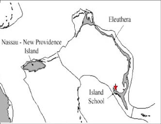
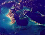
Eleuthera
Summer 2002
Geology and Topography of Eleuthera Island Eleuthera and its associated marine environment make up one of the six coastal systems on the Great Bahama Bank. The long arc of the island creates a sheltered bank environment to the west of the island. This is a typical long narrow Atlantic margin island, measuring about 90 miles long but rarely exceeding more than 3 miles in width. The largest land masses, and broadest parts of the island, are in the north and south, which also hold the largest water lenses, and to a lesser extent between Tarpum Bay and Rock Sound in the south.
Most of the island is narrow and hilly, especially in the north where there is a breach at the Glass Window. Between the Glass Window and Savannah Sound the island is unusual in having substantial cliffs on both shorelines. The geological structure in this area is a series of overlapping fossil sand dunes forming a low tableland frequently exceeding 100 feet in height. The highest point is 168 feet. Notable outlying islands, usually detached ridges, are Russell Island/St George’s Island (Spanish Wells), Current Island, Harbour Island and Windermere Island, all of which are inhabited. Low-lying rockland is limited in extent, but most evident in North Eleuthera, the name given to the triangular area north of the Glass Window; around Tarpum Bay; and in the far south.
The Eleuthera bank system forms the northeastern extremity of the Great Bahamas Bank, and has a strongly eroding coastline, with some evidence for bank margin collapse in the recent geological past, notably at Glass Window where the scalloped margin suggests bank margin retreat. The karstified surface limestone is generally sufficiently young to be scarified for agricultural purposes, and the island has been much altered by early plantation settlers and later subsistence farmers. Even today Eleuthera is an important agricultural producer with several large commercial farms.
Being in the northern part of the Bahamas, Eleuthera has a distinct if mild winter season, and is affected by cold fronts from North America. This also amplifies the winter rain in an otherwise dry season, but total rain overall averages just 50” at Rock Sound. Being on the Atlantic fringe it is in the direct line of the Northeast Trade Winds, which blow steadily all the year round, although they take on a more southerly (E-SE) orientation in summer. Summers are hot and relatively wet with most of the rain falling as heavy showers, or from tropical storm or hurricane activity. Eleuthera is in a higher hurricane risk zone than the southern Bahamas and was struck by both Andrew and Floyd in recent years.
HIGHLIGHTS OF THE SUMMER’S EXPEDITIONS
Water Quality Sampling around Island School – Teams IV and V conducted five days of dawn to dusk water quality sampling. The water quality sampling started at 6AM and ended at 8PM, with four people taking water samples every 2 hours. The samples were analyzed for dissolved oxygen, salinity, temperature and turbidity. Field measurements of current and horizontal secchi disk distance were also taken. The data showed tidal flushing around the peninsula, and the areas of freshwater input from the Island School. Water quality characteristics can be matched to wave energy and shoreline sediment composition to predict erosion and areas of water quality degradation.
Interviews with Local Government – College of Bahamas faculty Lionel Johnson and Lester Flowers carried out an interview process on environmental awareness and growth management. In a long-term environmental education plan, it is essential to identify what people perceive as the most critical environmental issues, and how people envision the island developing in the future. Eleuthera has had a long history of resort development and failure. A tremendous amount of environment degradation has occurred with little economic return. This questionnaire is the first part of a community development plan aimed at empowering local governments to make more informed development decisions. The product would be a government Master Plan for land use and long-term development.
Training of College of Bahamas faculty – An academic mini-grant from the Environmental Defense Fund funded four CB faculty to participate in the Earthwatch project. The lecturers received training materials, books and some equipment to apply the coastal survey methods and interviews to their courses at COB.
List of all Survey Stations on Eleuthera
OBJECTIVES
The research objective is to combine new technologies in remote sensing with landscape ecology to model biological diversity and fisheries production of shallow-water, tropical marine environments. New earth observation platforms have allowed better landcover mapping the coastal vegetation zones above and below the clear water of tropical islands. This research compares the coastal environments, level of coastal development and incidence of hurricane disturbance for ecologically similar islands in the Bahamian archipelago. This island group is ideal for the study of coastal ecology for several reasons: 1) the archipelago has a range of island sizes, 2) has a range of human development intensities, and 3) has had hurricane disturbances in the past 2, 3, and 4 years. On small tropical islands, the fluxes of nutrients from land to sea, and vice versa, are in critical balance. These systems are described as “oligotrophic”, meaning “few feeding” in environments where nutrients are limited, and algae production and diversity is dependent on nutrient recycling. Carbonate islands of the Bahamas are very sensitive to chronic eutrophication, or the addition of excess nutrients. The consequence of this nutrification is loss of marine diversity, and degradation of critical nearshore marine fisheries habitats. Fish habitat production is one measurable criterion that could be used to evaluate questions of sustainability for island systems.
There is growing evidence that humans are irreversibly changing the coastal zone with the chronic input of nutrients from non-point sources. This degradation of nearshore marine habitats is manifested in a loss of macroalgae diversity and production that are particularly important to fishes and marine life dependent on nearshore marine habitats as part of their life cycle. The Bahamian archipelago and the Florida Keys are made up of shallow-water carbonate limestone environments with few surface water resources; a critical feature is the continuous solutions of the limestone rock, and permeation of seawater beneath all the islands (Hoffmeister, 1974, Sealey, 1994). The marine and terrestrial habitats adjacent to the shoreline interact ecologically in terms of nutrient flux through rainfall run-off, seepage of ground water, and detrital material moving on and off the islands. Most people in these islands live within 2 km of the sea, and rely on nearshore marine resources for fisheries and tourism.
Threats to nearshore marine environments occur on several levels. The most severe threat is the physical elimination of habitats for the alteration and restructuring of the shoreline to accommodate marina, harbour, and residential development. A second threat comes from the acute and chronic sedimentation generated when coastal vegetation is removed, and the soil/sand exposed to erosion by rain during construction. Often exotic plants are used in landscaping, and native coastal plants are removed permanently leaving little or no vegetation buffer between buildings and the sea. Lastly, a threat exists, though poorly documented in the Bahamas specifically, from nutrient seepage from cesspits systems very close to the sea, or in contact with ground water. The common means of wastewater treatment and disposal is the use of septic systems or cesspit systems constructed on-site (US.EPA 1991; Cant, 1997). All on-site disposal systems installed on limestone islands are shown to enrich nearshore water with inorganic nutrients and some amount of organic matter (U.S. Environmental Protection Agency, 1983, 1991).
All of these threats can be mapped and integrated into spatial datasets. Although there has been much policy discussion of “sustainable development” of island systems, there remain no real ecological criteria to judge sustainability in these small, fragmented, and highly variable landscapes. This research seeks to refine a system of coastal habitat classification that is based on linking diversity of both land plant and marine macroalgae. Nutrient flux between land and sea can be evaluated by analysis of stable isotopes, particularly nitrogen, and an indication as to the source of organic detritus and nutrients to on-shore and near-shore primary production. However, there is no comprehensive spatial data set to guide field surveys to compare both nutrient flux rates and nearshore fisheries production. An analysis of the patterns of coastal development, coastal energy regime and disturbance history can be accomplished with the construction of a spatial dataset is GIS using existing data sources. From this information, one can address the question of sustainability: are there ecological criteria that can be used to measure over development of the coastal zone?
Using existing LandSat 7 imagery and habitat maps for the island of Eleuthera, the objectives for the 2002 field season were to:
1.) Survey as many different types of coastal environments as possible, including rocky shores, beaches, mangrove wetlands and developed shorelines.
2.) Develop a list of coastal plants and coastal plant communities by transect survey methods
3.) Develop a list of nearshore algae and epifauna communities by transect survey methods, and
4.) Establish baseline water quality conditions off the Island School, South Eleuthera as a potential restoration site.
These objectives were met with the help of 5 Earthwatch teams in the field for about 2 months.
METHODS
The methods employed in the field were fairly straightforward. Each team member was given a handout on the methods and example data sheets. Teams were divided into smaller groups during the day to participate in marine or coastal survey teams. A short description of the methods follows in Table 2.
Participants received training material in the form of datasheets and written protocols. This was the first summer for the project, thus many of the survey methods were new, and there were some revisions in the datasheets. The volunteers were a tremendous help in entering all the information into EXCEL spreadsheets for later analyses. The identification of macroalgae and plants was tedious, and a reference collection of both specimens and photos will be compiled for next summer’s work.
Table 2: A list of the research components and methods employed for each component. The methods were carried out by volunteers lead by a staff member. Volunteers rotated between groups to gain experience with all the different field methods.
|
|
||
|
RESEARCH COMPONENT |
METHOD |
DESCRIPTION |
|
MARINE TRANSECT |
TRANSECT PLACEMENT |
Ø Transects were placed perpendicular to shore out into the water for a distance of 60 meters. The transect length was dependent on depth, most surveys continued until a depth of 2 meters, |
|
RECORDING DEPTH AND TIDE |
Ø Every 2 meters, the depth along the transect line was recorded, the tide phase a the time of the survey was noted to identify the intertidal and littoral zones |
|
|
POINT INTERCEPT MEASUREMENTS |
Ø Every two meters, a 1x1 meter quadrat was placed on the bottom. A string grid identified 25 “point” on the bottom within the quadrat. Under each point, the bottom type or genus of algae was recorded. |
|
|
ALGAE BIOMASS MEASUREMENTS |
Ø - Every 10 meters along the transect, a “mini-quardat (0.06 m2) was placed on the bottom and all the algae inside was removed. At the lab, the algae was sorted into functional group or genera, dried then weighed. |
|
|
ALGAE SPECIES CHECKLIST |
Ø - A checklist of conspicuous macro-algae species was used to survey an area. All unknown algae were collected for laboratory identification. Algae were ranked as “occasional”, “common”, or “abundant” in an area 20 meters to either side of the transect line/ |
|
|
EPIFAUNA CHECKLIST |
Ø - A checklist of common invertebrate epifauna was used to characterize other benthos in the survey area. |
|
|
COASTAL TRANSECTS |
TRANSECT PLACEMENT AND SURVEYS |
Ø The Land Surveys extended from the water line perpendicular to the shore through coastal vegetation zones. The transect length was variable with coastal zone type. Every meter, elevation was recorded to map the shore profile. An electronic level (ZipLevel) was used |
|
PLANT SPECIES CHECKLIST |
Ø Field Botanists on the staff facilitated in the identification of plants along the transects. A plant list of vines, grasses, herbs and trees was developed. Every 10 meters along the transect line, a 5-m circle was surveyed for plant species present |
|
|
VEGETATION PLOTS |
Ø 5 x 4m plots were set up every 15 meters. Abundance and structure of plants were recorded on the data sheet. 2 small stem density plots were established in each of the larger vegetation plots. |
|
|
SEDIMENT COLLECTION AND ANALYSES |
Ø Coastal vegetation zones were identified along the transect, as pioneer, fore dune, back dune, swale, coastal coppice or mangrove. Sediment samples were collected from each zone, and returned to the lab. Samples were dried, sieved, and weighed to record the relative proportion of grain sizes to the substrate. |
|
|
INTERTIDAL MOLLUSK SURVEYS |
Ø A checklist of intertidal mollusks was used to evaluate the diversity of snails and bivalves in the intertidal zones (black, yellow, gray and white). |
|
|
WATER QUALITY ASSESSMENT |
COLLECTION OF WATER SAMPLES |
Ø Water samples were collected 0.5 meters below the surface at 7 water quality-sampling stations around the Island School peninsula. Stations were 10m and 30m from the low-tide mark. Samples were collected from 6 AM to 8 PM every two hours throughout the day |
|
ESTIMATES OF TURBIDITY AND CURRENT |
Ø At the water quality sampling stations, estimates of turbidity were made with horizontal Secchi disc readings, and current estimates were made with Fluorescent dye trails. |
|
|
LAB ANALYSIS OF WATER SAMPLES |
Ø Water samples were brought immediately to the lab in coolers for analysis of temperature, salinity and dissolved oxygen. Measurements were made with a YSI 85 probe, and a refractometer. |
|
|
GROUND-TRUTHING |
Identification and description of landcover classes |
Ø Landcover mapping was verified by visiting places on the island that were classified as “wetlands” or “agriculture”, then recording the Global Positioning System (GPS) position. |
|
SURVEYS ON DEVELOPMENT AND GROWTH MANAGEMENT |
Questionnaire for local government officials |
Ø A growth management survey was carried out by College of the Bahamas staff to get an initial view of local attitudes about what environmental issues are most important, and who has responsibility for environmental management and clean-up. |
VOLUNTEER TASKS and ACCOMPLISHMENTS
Table 3: A list of the Earthwatch teams fielded during the 2002 season. The maximum number of volunteers on each team was 12. Each team made unique contributions to the coastal survey database.
|
|
||
|
Team/ Date |
Number of Volunteers |
Accomplishments |
TEAM I: 11 – 21 June |
12 |
This team completed 19 coastal surveys, often doing surveys in both the morning and the afternoon. The weather was the coolest during this team, and we had lots of enthusiasm the first 10 days in the field |
|
TEAM II: 22 June to 2 July |
12 |
This team completed 16 coastal surveys, and tackled some very large dunes. Two College of the Bahamas faculty participated with this team. We learned some important lessons on tidal cycles in mangrove creeks. |
|
TEAM III: 8 July – 18 July |
12 |
Team III tackled the Schooner Cays to the west of Eleuthera, as well as the altered dunes of Cotton Bay. A total of 11 coastal surveys were completed. The channel net was assembled for deployment |
|
TEAM IV: 19 July to 29 July |
11 |
Team IV worked in the full heat of the summer, and completed 11 coastal surveys, with two days of water quality sampling. This team also returned to the westernmost Schooner Cay to complete surveys and see nesting gulls and white-crown pigeons. |
|
TEAM V: 30 July to 9 August |
11 |
Team V finished 3 days of water quality sampling, and 12 coastal surveys, including the detailed mapping of the Island School peninsula |
With the help of field botanist Keith Bradley, we have started an analysis of plant communities found in different coastal zone environments. Table 4 lists the plants recorded for south Eleuthera; the scientific names are based on the “Flora of the Bahamian Archipelago” by Correll and Correll.
The past summer’s experience has taught us the importance of having 4 or 5 well-trained staff and graduate students in the field with the volunteers. The first few days of training are critical for each team, and the productivity of the team depends on volunteers receiving training in small groups. We will look to develop more collaborations with College of the Bahamas and with University of Miami graduate students to increase our field staff for each team.
RESULTS
A. Diversity of Coastal Plants and MacroAlgae
This was the first time that a comprehensive list of coastal plants and coastal plant communities has been compiled for the Bahamas. The research helped contribute some basic ecological information on the coastal zone of the central Bahamas. We characterized several important shoreline types, their extent and characteristic native plants and nearshore marcroalgae diversity.
B. Differences in High-energy and Low-energy coastal environments
High-energy shorelines had more macroalgae species than low-energy shorelines. The substrate (rocky or sandy) had little effect on macroalgae diversity. Figure 1 presents the mean number of macroalgae species reports along the transects, data are presented by shoreline energy and substrate categories.
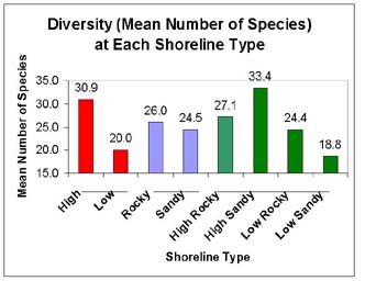
Mean number of macroalgae species found on the marine transects at unaltered shorelines in South Eleuthera. High energy shorelines, regardless of substrate, had more algae species than low energy shorelines.
C. Impact of Development on coastal diversity
For both high and low energy shorelines, human development tends to decrease overall diversity of plants and macroalgae. Intact coastal vegetation communities support a more diverse and productive benthic community offshore. This relationship suggests that intact coastal environments have a flux of nutrients and organic matter that may be easily disrupted by building and destruction of the coastal vegetation. Vegetation buffer zones may do more than protect coastlines from erosion; coastal plant communities may be tied ecologically to nearshore algal diversity and thus the quality of fish habitats.
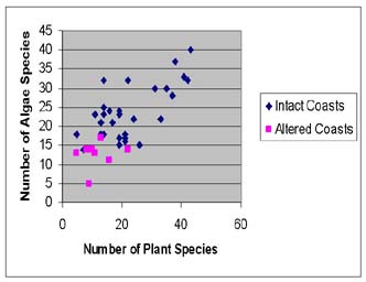
Relationship between coastal plant diversity and benthic macroalgae diversity of intact and altered coastal environments of south Eleuthera
D. Water Quality studies of Island School Site
Water quality sampling around the Island School showed distinctive differences in water quality on the 5 transects. The 5 transects were arranged from east to west. Transect 1 was in the shallowest water, Transect 5 in the deepest (dredged) water. Temperature can serve as a proxy for circulation, with Transects 1 and 5 experiencing the greatest temperature extremes, and the lowest tidal flushing.
From the water quality sampling, temperature and salinity were the master variables, describing water mass movement, and the input of freshwater. Transect 5 was in the finger canal to the west of the island school, and showed the poorest water quality of all sampling stations. Dissolved Oxygen was low throughout the day, with turbidity high. Several algae blooms were observed in the canal over the course of the summer. Because of the fill nature of the peninsula, the canal will receive freshwater seepage from run-off, watering and the waste water treatment system on campus. This is evident from the decrease in salinity, and high turbidity that persists in this area.
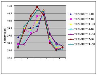
Salinity (ppt from calibrated YSI 85 probe) records from 5 transects from dawn to dusk on 5 August 2002
E. Epifauna Diversity
The checklist of Epifauna species observed around the Island School may be viewed in Table 5.
DISCUSSION
Describe how this year's findings contributed to your broader research goals:
This year was extremely successful. We were able to visit very diverse coastal environments around the island both by vehicle and by boat. There is a great deal of work to do now in the laboratory to process the data and produce the coastal zone maps for south Eleuthera.
The next stages include:
a. Planning then implementing a coastal restoration project. This may be staged at the Island School.
b. Surveys of a different island with different coastal environments. Andros island has been selected for the 2003 field season.
A restoration plan has been drafted and sent for review for the 2003 field season.
The 2002 field season contributed important information in several areas of coastal zone management policy:
Ø College of Bahamas staff were able to see first hand the threats to the coastal environments of the Bahamas. This information can be incorporated in the Environmental Studies program at the college, and can be used for case-study material in an environmental policy class.
Ø We were able to host a visit from Mrs. Angela Cleare from the Ministry of Tourism, Government of The Bahamas. She was able to see the field work used to create coastal zone maps, as well as the identification of high threat areas.
Ø The benthic mapping component of the project is a direct benefit to the Department of Fisheries in characterizing important fisheries habitats
Since the end of the field season, three separate presentations have been made to government ministries about the information generated by this work. A web site has been set up to disseminate information from this and other research projects in the Bahamas (see http://islands.bio.miami.edu).
PUBLICATIONS
(a) List publications, presentations, articles, or films completed or in progress resulting from this project.
The results from this past summer’s work will be written up as part of research articles for the following journals:
Ø Conservation Biology
Ø Caribbean Journal of Science
Ø Coral Reefs
Ø Frontiers in Ecology
Ø Bahamas Journal of Science
(b) For previous field work sponsored by Earthwatch, attach copies or reprints of completed scientific or popular publications that we have not yet received.
Not available at this time
OTHER ACCOMPLISHMENTS AND BENEFITS
Describe any other benefits resulting from your project, such as teacher or student training, local community education or economic development, supplemental funding, publicity, etc.
ACKNOWLEDGMENTS
Principal Investigator |
Kathleen Sullivan Sealey |
|
|
Position/ Title/ Organization/ Affiliation |
Associate Professor, Department of Biology University of Miami |
|
|
Address - |
U.S. Postal Service: Department of Biology P.O. Box 249118 University of Miami Coral Gables, Florida 33124 USA |
Express Mail, UPS or Courier: Room 25, Cox Science Center 1301 Memorial Drive University of Miami Coral Gables, Florida 33146 |
|
Phone and e-mail contacts |
305 284-3013 |
|
|
Co-Investigator |
Mr. Lester Flowers Senior Lecturer |
|
|
Address and Contact |
School of Natural Sciences and Environmental Studies P.O. Box N-1249 College of the Bahamas Oakes Field Campus Nassau Bahamas 242 362-5824 (home)
|
|
|
Teams |
TEAM I: 11 – 21 June 2002 TEAM II: 22 June to 2 July 2002 TEAM III: 8 July – 18 July 2002 TEAM IV: 19 July to 29 July 2002 TEAM V: 30 July to 9 August 2002 |
|
|
Total Number of Volunteers |
58 |
|
|
Vanessa Nero |
Graduate student |
University of Miami |
|
Corene Luton |
Graduate student |
University of Miami |
|
Keith Bradley |
Field Botanist |
Regional Conservation Initiative, Miami, Florida |
|
Marlene Jackson |
Lecturer |
College of the Bahamas |
|
Alan Jackson |
Teacher |
Nassau, Bahamas |
|
Rena Booth |
Lecturer |
College of the Bahamas |
|
Daniel Loewenherz |
Student Intern |
Ransom Everglades School, Miami, Florida |
|
Bridgett Hogg |
Lecturer |
College of the Bahamas |
|
Jill Engel Cox |
Graduate Student |
University of Maryland |
|
Natalie Brady |
Student |
University of Miami |
|
Ivan Sealey |
Computer and Web site consultant |
Cable and Wireless, London, UK |
Coastal Ecology of the Bahamas